Thursday, December 10, 2009

Delhi

 National Capital Territory of Delhi: Cities and Vacations


The National Capital Territory of Delhi lies almost totally in the Gangetic plains.
Towards the East is the state of Uttar Pradesh. In the South, North and West the state of Haryana borders Delhi.

The significant characteristics of Delhi are the Yamuna flood plain as well as the Delhi ridge.
The weather of Delhi territory is semi-arid : from early April to October is the summer season accompanied by the monsoon, whereas, on the other hand, from October the winter season begins and this peaks in January.

This season is adversely reputed for heavy fog. The average yearly rainfall is about 714 mm. Of these the maximum part is in July and August. The temperature can be as high as 47 °C or as low as -0.6 °C. As per the 2001 census, the population of Delhi was 1,37,82,976.

In Delhi territory, there are several ethnic groups and cultures.

There are also considerable expatriates. Both blue collar and white collar workers from all corners of the country are enticed towards Delhi.

All these factors make Delhi a truly cosmopolitan city.

Tamil Nadu


Tamil Nadu: Introduction and History
This state was in existence since prehistoric times and is known as the native land of the Tamils with a history going back to several thousand years.
Tamil Nadu is one of the most developed states in India comprising of a variety of unusual flora fauna, beautiful hill stations, tranquil beaches, ancient pilgrimage sites and stunning Hindu temples.
With a coastline of more than 1000Km, Tamil Nadu had beautiful serene beaches.
The local language largely spoken in this state is Tamil apart from Sanskrit.
Chennai, earlier known as Madras is the capital of this state.
Tamil Cuisine is amongst the most erstwhile culinary inheritances in the world. Its unique dishing out of food in a banana leaf instead of a plate is one of the reasons why tourists from all over enjoy this cuisine.
The St. Thomas Mount in Chennai, the Santhome Basilica built upon the mausoleum of St. Thomas, the picturesque hill stations of Coonoor, Yercaud, Kodaikanal and Udhagamandalam along with a variety of national and wildlife parks and sanctuaries are the star attractions of this beautiful scenic state.
All the cities in Tamil Nadu
Chennai Chidambaram Coimbatore
Kanchipuram Kanyakumari Kodaikanal
Madurai Mamallapuram Ootacamund
Ooty Selam Thanjavur
Tiruchirappalli Tirupur Udhagamandalam

Meghalaya


Literarily meaning ‘The Abode of Clouds’ (in Sanskrit) the north eastern state of Meghalaya, with a population of just over 2 million people, is a hilly strip with about one-third of the state being forested, is about 300 km long and 100 km wide is a small state in north-eastern India.
With majority of the population being made up of tribal people dominated by three main sects, Meghalaya is currently one of few states in India to have as high a Christianity population of over 70%.
The state made up of many rivers and mainly built on rock formations contains rich deposits of valuable minerals.
As described by its name, Meghalaya is considered one of the wettest states in the country with an average rainfall as high as 1200 cm, and its climate being moderate but humid and its economy predominantly agrarian
All the cities in Meghalaya
Cherrapunjee
Jongohetpara
Phlangmawphra
Ringkhap songmong
Shillong
-

Himachal Pradesh


 The state of Himachal Pradesh was formed by the unification of 30 princely states following Independence from the British Rule in 1947.
With population of around 7 million, this traditional state of Himachal Pradesh, which has been influenced minimally by external cultures, is bordered by Jammu & Kashmir to its North.
Known for having one of the highest per-capita income in the country and sometimes referred to the land of Gods, the state has a great variation in climatic conditions owing to its great disparities in elevations between locations.
With over 60% under forest area, the State is also known as the fruit bowl and has a continuous supply for water from the numerous rivers that flows through it.
This has resulted in Hydro power and agriculture becoming a major contributor to the revenue with a large amount being sold to neighbouring states too.

All the cities in Himachal Pradesh
Dharamsala Kullu Manali
McLeod Ganj Shimla

Daman and Diu


Daman is located on the West coast of India. This Union Territory was earlier referred to as ‘Damao’.
Gujarati and Marathi are the languages spoken here apart from the much frequently spoken English which is acknowledged for official purposes.
The spots frequented by tourists are the amusement park on Devka beach and Nani Daman which refreshes the visitors apart from other Beaches, gardens, churches.
In Diu, the beautifully secluded beach, Nagoa is one of the most spectacular beaches in India and the distinctive shoe shape of the beach makes it all the more stunning.
The island of Diu is located just off the Saurashtra coast of Gujarat which borders the Junagadh district.
The maximum temperature in summer is 36 C and the minimum temperature is 20 C while in winter the maximum temperature is 26 C and the minimum is 20 C again.
The best time to visit this place is from October to May.

Andaman and Nicobar Islands

Andaman and Nicobar Islands: Introduction and History


The Andaman and Nicobar Islands are situated in the Indian Ocean, and Port Blair, an Andamanese town, is the capital of this Union Territory.
Dwelt in for more than several thousand years proof of life on these islands goes back to about 2000 years. Totally there are 572 islands in this territory of which only 38 are permanently habitated.
Home to numerous aboriginal tribes, Andaman is derived from the Mythological God Hanuman.
Nearly 86% of the total area of this territory is covered by lush forests. The Mahatma Gandhi Marine National Park is plentiful in its assortment of animals, fish, turtles etc.
The best season to visit these islands is from October to May.

Friday, December 4, 2009

Tabasco

Tabasco: Introduction and History


Tabasco, Mexico has an area of 25,267 sq km and a population of about 1,989,900. Its capital is Villahermosa.
Tabasco, situated on the edge of the Gulf of Mexico, is bounded by the Mexican states of Campeche, Guatemala, Chiapas and Veracruz. The state is mostly covered with plains, with a large number of lakes, rivers and forests.
Tabasco is principally populated with Mestizos (mixed indigenous and foreign ancestry) and Chontal Indians. It has also remained a Spanish colony.

Villahermosa
Villahermosa is the capital city of Tabasco, Mexico. It was formerly known as San Juan Batista, with the present name being adopted in 1915. Villahermosa means a beautiful village in Spanish. It is surrounded by the Carrizal, Grijalva and Mezcalapa rivers with a population of over half a million inhabitants.
Villahermosa is typified by a tropical climate with hot and humid summers and short winters and high humidity levels. The most remarkable season is springwith blooming flowers and tropical vegetation; it is also an ideal time to visit.
Villahermosa is a city known for its natural resources, agriculture and farming. It is home to Tabasco’s major political powers in addition to being an important business centre. Villahermosa is also engaged in manufacturing processed foods, clothing, wood products, etc.

Odense

Tourist guide Odense


Odense is the capital of Funen, one of Denmark’s main islands. Numerous large and well-maintained fields have led to the city being labelled ‘The Garden of Denmark’.
Hans Christian Andersen’s city to literary enthusiasts, Odense is also one of Denmark’s premier industrial centres. Almost one thousand years old, the city today is home to more that 185,000 inhabitants.
Odense has a typically temperate maritime climate with pleasant summers and cold winters. Summer is the best time to visit with an average temperature of 20.6°C.
In the Middle Ages, Odense was a pilgrimage site, but by the sixteenth century the town gained in political stature and became the spot for many parliaments to converge. Today, it is houses Denmark’s biggest shipyard.


My title

page contents

Thursday, December 3, 2009

Florida


Florida has an area of 170,304 sq km and a population of around 16 million people. Its capital city is Tallahassee.
Florida is one of the south-eastern states of the USA. It makes up most of the peninsula lying between the Gulf of Mexico, the Straits of Florida and the Atlantic Ocean. The state is bordered by Georgia in the north and by Alabama in the west. Britton Hill is the highest point in Florida at 105 m.
All the cities in Florida
Alachua Altamonte Springs Amelia Island
Anna Maria Apalachicola Apollo Beach
Arcadia Atlantic Beach Aventura
Avon Park Bal Harbour Boca Grande
Boca Raton Bokeelia Bonita Springs
Boynton Beach Bradenton Bradenton Beach
Braderton Beach Brandon Brooksville
Bushnell Cape Canaveral Cape Coral
Captiva Island Cedar Key Celebration
Chipley Clearwater Clearwater Beach
Clermont Clewiston Cocoa
Cocoa Beach Coconut Grove Coral Gables
Coral Spring Crystal River Cutler Ridge
Dade City Dania Davenport
Davie Daytona Beach Deerfield Beach
Defuniak Springs DeLand Delray Beach
Deltona Destin Doral
Duck Key Dunedin Dunnellon
Ellenton Eustis Everglades City
Fernandina Beach Florida City Fort Lauderdale
Fort Myers Fort Myers Beach Fort Pierce
Fort Walton Beach Gainesville Gibsonton
Gulf Breeze Haines City Hallandale
Hamptons at Boca Raton Hawthorne Hialeah
Hialeah Gardens Hobe Sound Hollywood
Holmes Beach Homestead Homosassa
Homosassa Springs Howey-in-the-Hills Indialantic
Indian Rocks Beach Indian Shores Inverness
Islamorada Jacksonville Jennings
Jensen Beach Jupiter Kenansville
Kendall Key Biscayne Key Largo
Key West Key West Keys Kissimmee
Labelle Lady Lake Lake Buena Vista
Lake City Lake Mary Lake Wales
Lake Worth Lakeland Lantana
Largo Lauderdale by the Sea Lehigh Acres
Longboat Longboat Key Longwood
Madeira Beach Maitland Marathon
Marco Island Marianna Melbourne
Melbourne Beach Merritt Island Miami
Miami Beach Miami Gardens Miami Lakes
Miramar Mount Dora N. Redington Beach
Naples Navaree Neptune Beach
New Port Richey New Smyrna Beach Nokomis
North Miami North Port Oakland Park
Ocala Ocoee Okeechobee
Oldsmar Orange City Orange Park
Orlando Ormond Beach Oviedo
Palatka Palm Bay Palm Beach
Palm Beach Gardens Palm Coast Palm Harbor
Palmetto Panama City Panama City Beach
Pembroke Pines Pensacola Perdido Key
Perrine Plant City Plantation
Polk County Pompano Beach Ponce Inlet
Ponte Vedra Beach Port Charlotte Port Orange
Port Richey Port Saint Lucie Port St. Lucie
Redington Shores Reunion Riviera Beach
Safety Harbor Saint Cloud Saint Pete Beach
Sanford Sanibel Sanibel Island
Santa Rosa Beach Sarasota Satellite Beach
Sebastian Sebring Seminole
Siesta Key South Beach South Miami
Spring Hill St Augustine St Petersburg
St. Cloud Starke Stuart
Sunny Isles Beach Sunrise Tallahassee
Tamarac Tampa Tarpon Springs
Tavares Temple Terrace The Villages
Titusville Treasure Island Venice
Vero Beach Weeki Wachee West Palm Beach
Weston Wildwood Winter Garden
Winter Haven Winter Park Yulee
Zephyrhills Zolfo Springs -

Perce

Tourist guide Perce
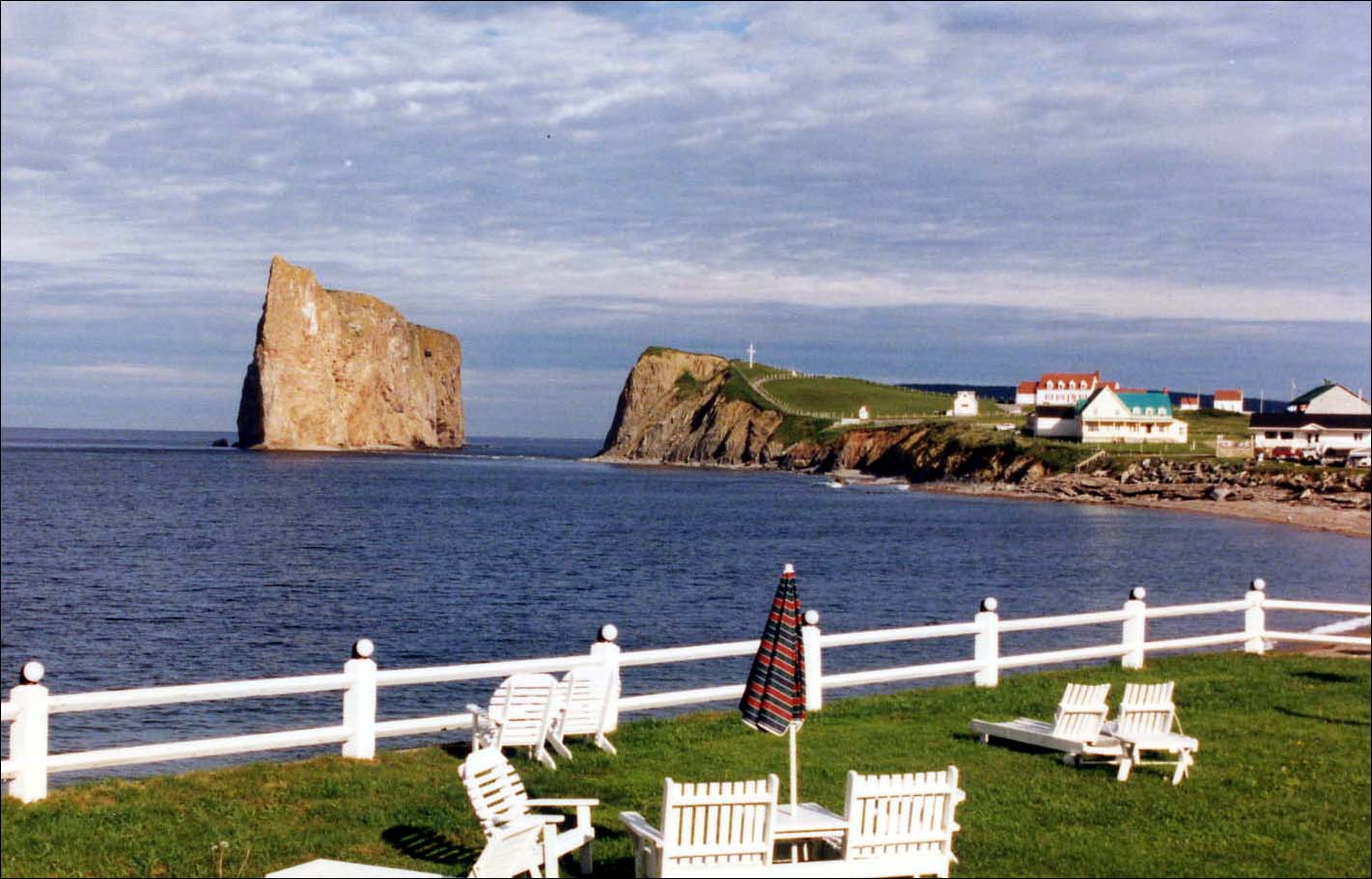
In Quebec, Canada, close to the tip of the Gaspe Peninsula is a tiny village called as Perce. The area of this village as a municipality is 432.39 square kilometers. The main attraction in this village is Perce Rock.  The other known attractions are the Interpretation Center, several souvenir shops, Bonaventure Island, Hote Cousing, museums and scenic trails. People from all over the world are enticed towards this fascinating village each year. The tourists usually enjoy several local artists of Gaspe. Those who visit the Bonaventure Island can see almost one hundred types of birds like puffins, sea gulls, gannets and the popular fou-bassin. Those who are fortunate may even see a whale.

As per the 2006 census, the population of Perce was 3419.

Perce has four seasons throughout the year. Spring is from April to the end of June. Winter is from November to the end of March. Fall is from September to the end of October. Summer is from the end of June to the end of August.